Loading…
See what your students are learning, live.
Students play through 11 maps of missions, lessons, and mini-games. You get a dashboard that shows who has mastered which geography standards, for your state, as they play.
Sign in with your school Google account. No payment details. The World map stays free after the trial.
Up and running in three steps
No rosters to upload, no student emails needed, nothing to install.
Sign in with your school Google account, name your class, and pick your state. Your students will see your state's standards.
Students go to geojag.com/students.html and type your 6-letter class code. Schools that set it up can also use school Google sign-in.
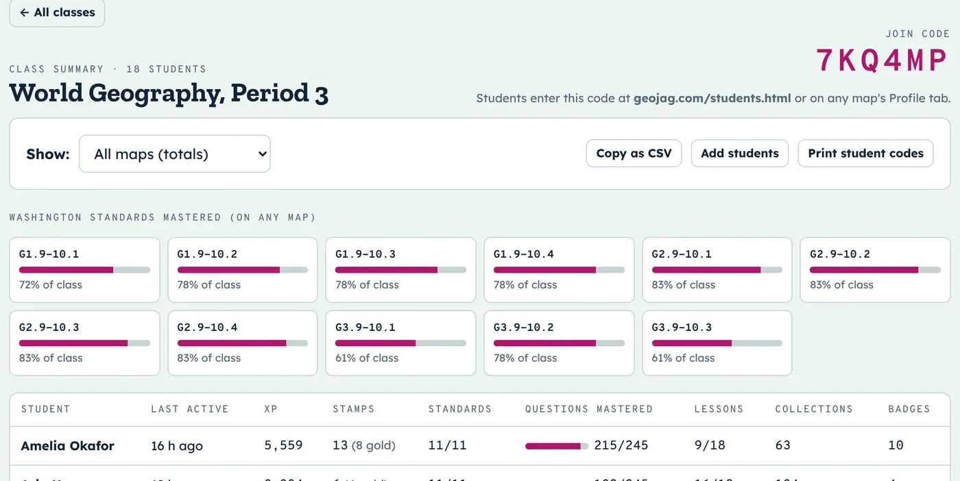
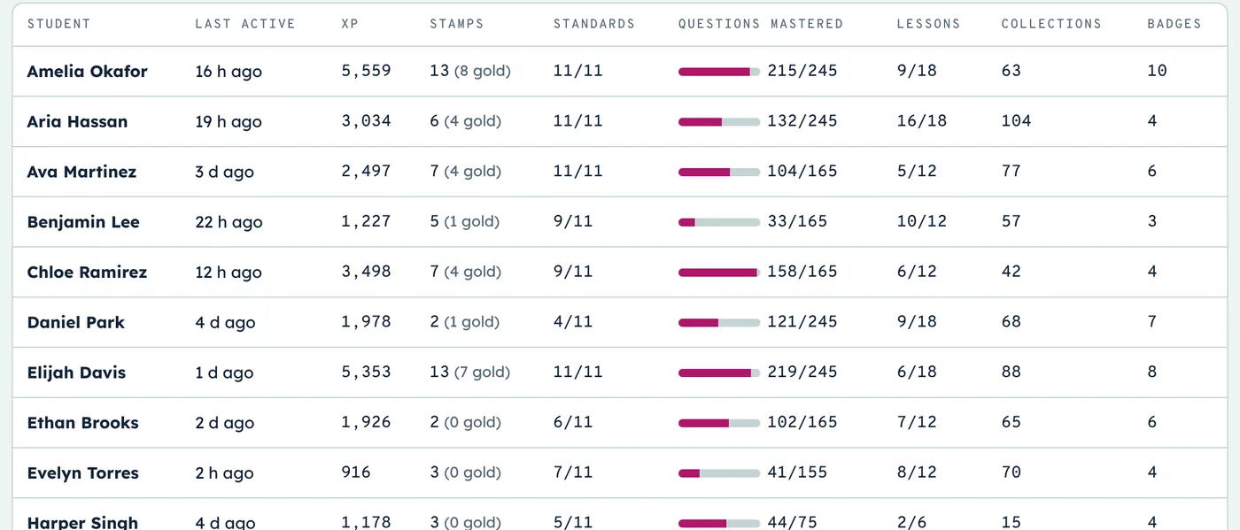
Your dashboard updates as students play: XP, passport stamps, lessons, and standards mastered.
Know who's mastered what, at a glance
Each standard shows the share of your class that has mastered it. A student masters a standard by earning a passport stamp in every mission that practices it, so mastery means repeated success, not one lucky answer.
- Filter to one map or see totals across all of them
- Copy the whole class as a spreadsheet (CSV)
- Spot who hasn't played lately
Every student's passport, in detail
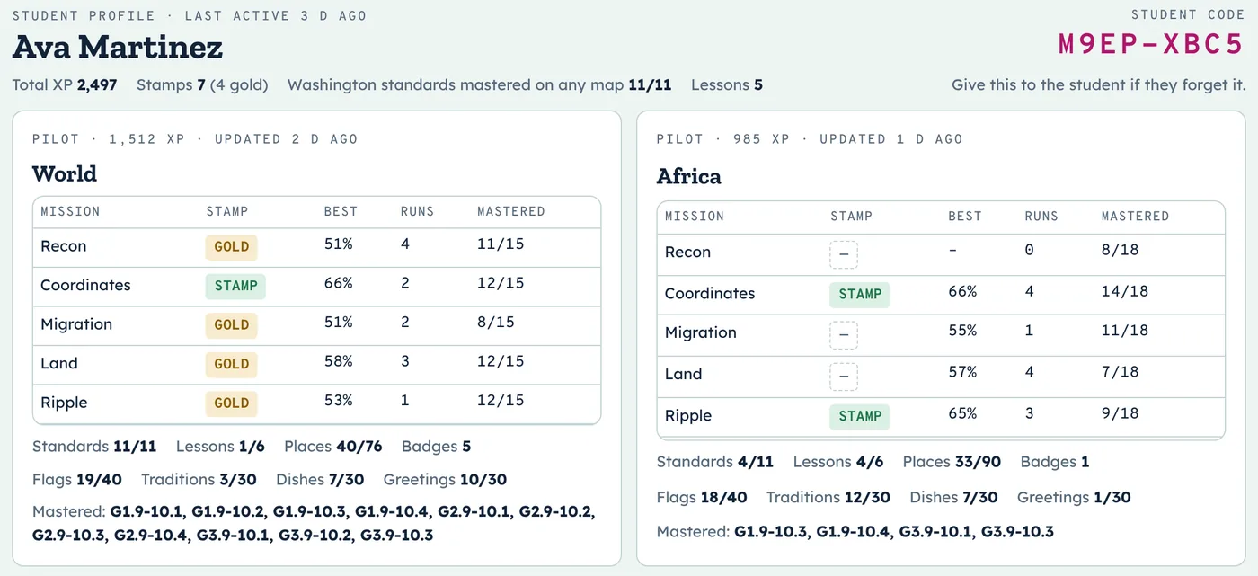
Click any student to see their stamps, best scores, attempts, and questions mastered for each mission on every map they've played, plus lessons, collections, and the standards they've mastered.
- Great for conferences and IEP check-ins
- Their private student code is right there if they forget it
Print codes, hand them out, done
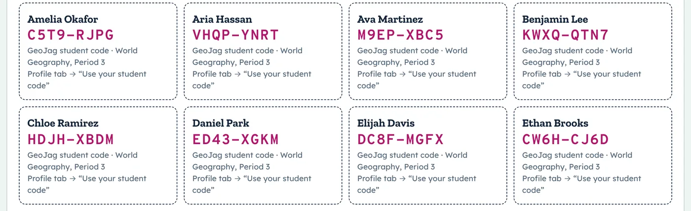
Add students yourself or let them join with the class code. Either way, every student gets a private code to sign back in on any device. Print them as cards in one click.
A ready-made entry task, every day
The Daily Challenge is a timed Country of the Day: students find it on the map, then match its flag, a tradition, a dish, and a greeting. Everyone gets the same country that day. Put it on the board as students walk in. Your dashboard shows who finished, their scores and times, and each student's last 10 school days.
Locate it, then the four mini-games. About two minutes, and right answers fill in students' flag album and collections.
Students signed in to your class send their first try each day to your dashboard. Replays are practice and don't change the score. You also see each student's active minutes per day, and only you see them.
Students get a spoiler-free result to share, plus a link that challenges friends to beat their score.
A story, a crew, and a reason to keep going
Students fly as Jag's co-pilot. Jag is a young pilot from Jaipur, India. On each regional map they land in a new city and meet a friend, like Sofía in Oaxaca, Kwame in Kumasi, or Min-jun in Busan, who briefs each mission and joins the crew when the student earns all five stamps.
XP pays out in each region's currency: rupees, pesos, cedis, won, đồng, and more. Prices show local amounts next to U.S. dollars, so students see what an exchange rate means.
Students spend their money at local markets on clothing and styles like an Aran sweater, a kente stole, or a nón lá. Each item comes with a short note on where it comes from. Hijab, turban, and glasses are always free on the Look tab.
It's off unless you turn it on. When on (in classes of 10 or more), students see the top five pilots by XP this week or all time, shown by first name and last initial.
Plus sound effects (off until a student turns them on), stamp and badge celebrations, and a pilot avatar that follows each student to any device. The World map's story and Jaipur market are free for everyone.
Built-in supports for ELL and IEP students
Turn on supports for individual students from their profile on your dashboard. They follow the student to any device, and students see only their tools, never a label.
Read aloud for questions, choices, lessons, and feedback, plus a glossary of key geography words with simple definitions.
Fewer answer choices, no Daily Challenge timer, and shorter 5-question missions that still earn stamps and standards.
GeoJag stores only which supports are on, never why. Only you can see or change them.
For students who are blind or have low vision, see the accessibility statement. Aligned to WIDA. Pick a student's WIDA proficiency level (1–6) and GeoJag sets matching supports. See the WIDA alignment and sentence frames for every mission.
Aligned to your state
GeoJag was built on Washington's high school geography standards and aligned to the national C3 Framework and every state. Pick yours to see what your students will practice.
Deeper thinking, and data you can act on
GeoJag asks students to explain, not just click, and shows you what to reteach.
After each mission, students write a few sentences with sentence starters at three levels. You score each response 0–3 (claim, evidence, reasoning) on your dashboard.
On every map, a crew member asks for advice on a real problem, like Jaipur's water or the shrinking Aral Sea. Students weigh evidence, choose, and defend it. There's no single right answer.
A question counts as mastered only after it's answered right on two different days, and stamps require passing on questions the student hasn't seen before. Replays earn less XP.
See which questions your class misses most, and the wrong answer they chose most often, so you can target misconceptions.
Assign a mission with a due date and track who's done. Click any standard to see who still needs it.
A printable page for every mission: objective, vocabulary, warm-up, discussion questions, and an exit ticket with an answer key. See the guides.
What students do
Every map has the same five missions, short lessons to learn first, and mini-games that make each country memorable.
Plus flag, culture, food, and language mini-games, ranks from Flight Cadet to GeoJag Ace, and a passport full of stamps.
A sample week
One way to use GeoJag alongside a regional unit. Open each day with the Daily Challenge as an entry task; missions are short, so each day leaves room for your own teaching.
Questions teachers ask
Do students need email addresses or accounts?
No. Students join with your class code and get a private student code. If your school sets it up, they can sign in with their school Google account instead.
Will it work on our school's network?
Usually, yes. Students join with a class code, with no Google Workspace setup. To be sure, open the 30-second network check on a student Chromebook. If your web filter blocks anything, it writes a note for your IT team. Your free week doesn't start until your first student joins, so a quick IT fix won't use it up.
Does it work on Chromebooks?
Yes. GeoJag runs in the browser on Chromebooks, laptops, tablets, and phones. Nothing to install.
Which standards are covered?
Washington's grades 9–10 geography standards, the C3 Framework, and a best-fit alignment for every other state. See your state's alignment.
How do I try every map?
The World map is free. Start a free one-week trial on the teacher dashboard to unlock all ten regional maps, or ask about a school pilot.
What about student privacy?
GeoJag stores only a student's name, their school email if they use Google sign-in, and their game progress. No ads, and data is never sold. We'll sign your district's data privacy agreement. Read the privacy notice.
What happens after the free trial?
Your classes keep the free World map and all their progress.
Try every map free for one week
Set up your first class in about a minute.